
PVWMA
MCWRA
RCDMC
Central Coast Agrciultural
Water Quality Coalition
Responding to drought conditions
2013 was the driest year on record for much of California (DWR, 2014). Monterey County had record low precipitation that year, and in 2014 remains under the U.S. Drought Monitor’s highest (worst) drought designation category D4, denoting exceptional drought (Schmalz 2014; USDA/NOAA 2014).
In response to the worsening drought, Governor Brown urged Californians to take measures to reduce water consumption by 20% (Office of the Governor 2014). Despite reducing water use by approximately 10% on the Central Coast, an overall statewide water use increase of 1% in May prompted the State Water Resources Control Board in July to pass mandatory restrictions on urban water uses, enforceable through fines (SWRCB 2014).

The level of Lake San Antonio in early fall, 2013. This “lake” is one of the primary reservoirs feeding the massive Salinas Valley Groundwater Basin growers rely on to irrigate crops.


Photo provided to Salinas Californian courtesy of Central Coast Bass Fishing.
Top: regional precipitation trends.
Bottom: Drought severity statewide
Source: Western Regional Climate Center, 2013; USDA/NOAA, 2014, California Drought Monitor
California Water Bond and the Sustainable Groundwater Management Act
In August, 2014, Governor Brown approved AB 1471, putting a $7.545 billion water bond on the ballot in November, 2014 for California voters under Proposition 1 (Office of the Governor 2014). The Central Coast would receive $43 million for integrated regional water management projects, $100 million for water conservation and water-use efficiency, and $200 million for multi-benefit storm water management. These funds would improve water management in the region, and increase water recycling and aquifer recharge while improving river and habitat protection (Monning 2014).
In September, 2014, Governor Brown signed three bills (AB 1739, SB 1168, and SB 1319) comprising legislation to create California’s first regulatory framework aimed at achieving sustainable groundwater extraction rates, known as the Sustainable Groundwater Management Act. The Act targets areas where groundwater basins are being depleted faster than they are being replenished to be sustainable by 2040 (Nirappil and Giwargis 2014). By January 31, 2015, the Department of Water Resources must list and prioritize all groundwater basins in overdraft and publish the list in Bulletin No. 118 (Alston & Bird, LLP 2014). The Act requires local agencies to form a single Groundwater Sustainability Agency (GSA) in their region, authorized to impose regulatory fees on pumpers to fund the creation and implementation of a Groundwater Sustainability Plan (GSP). Such costs can include acquiring land and groundwater recharge projects and monitoring the level of wells. A GSA can also: limit the number of wells via well-spacing rules; set groundwater extraction allocations; enter private land to inspect wells and pumps within their jurisdiction through a court-issued warrant; and levy fines and civil penalties against non-compliant users. Failure to comply with the warrant is a misdemeanor crime (Alston & Bird, LLP 2014).
By June 30, 2017, local agencies or GSAs must assume responsibility to implement the Act. By January 31, 2020, GSAs or local agencies in overdrafted basins must submit GSPs to the State Water Resources Control Board for review. By 2022, other high and medium priority basins not in overdraft must have such plans. By 2040, all high and medium priority groundwater basins must achieve sustainability (The Office of the Governor 2014; Alston & Bird, LLP 2014). If the board determines a GSA violated the Act and failed to remedy the situation within a required timeframe, the board can fine the GSA or assume management of the basin to reach compliance after holding hearings (Alston & Bird, LLP 2014; Weiser 2014).
See the attached fact sheet for more information, provided by the California State Association of Counties.
Irrigation demand
The Salinas Valley Groundwater Basin is the main source of water in the Salinas Valley for both agricultural and urban uses. Agricultural uses accounted for approximately 90% of average groundwater withdrawals in the Salinas River Groundwater Basin over the past decades. However, water use efficiency improvements and changes in irrigation systems from surface and sprinkler irrigation to drip irrigation have led to decreased overall agricultural water use. This decrease occurred despite irrigating more crop acreage amidst urban and residential use increases. In 2010, growers in the Salinas Valley pumped an estimated 416,421 acre feet (AF) of water compared to 611,384 AF in 1972—over 30% of a reduction in total use despite irrigating more cropland and intensification of drought (IRWMP 2013). The following graphs show total water demand in the Salinas Valley Groundwater Basin from 1995-2012 in acre-feet per year (AFY) and the changes in the number of acres irrigating under different irrigation methods from 1993-2013. Most notably, major reductions in the use of sprinkler and furrow irrigation accompany steady increases in using drip irrigation over the same period.
Despite the efforts to reduce water use, drought continues to severely exacerbate water issues on the Central Coast. The drought has already led to the “greatest water loss ever seen in California agriculture” (Howitt et al 2014).
Left: Salinas Valley Groundwater Basin. Source: MCWRA 2013, Groundwater Extraction Summary Report 2012.
Top right: Total water extraction in the Salinas Valley Groundwater Basin (acre-feet). Source: adapted from MCWRA 1996-2013, Groundwater Extraction Summary Reports 1995-2012.
Bottom right: Irrigation methods by acres of farmland 1993-2013. Source: MCWRA 2013, 2012 Groundwater Extraction Summary Report, p. 5.


Seawater intrusion
The basin averages 50,000 acre-feet of overdraft in non-drought years, and estimates for drought years reach 150,000-300,000 acre-feet. Such consistent overdraft causes groundwater elevations to drop below sea level, allowing seawater to enter from the Monterey Bay into the Pressure Subarea 180-Foot and 400-Foot Aquifers (IRWMP 2013). The maps at right show the extent of seawater intrusion into those aquifers from 1946 to 2011. The Eastside subarea used to naturally provide recharge to the Pressure aquifers while controlling seawater intrusion, but overdraft has reversed the underground flow and prevented both the natural recharge and protection from seawater intrusion (MCWRA 2013: 3-4).


Groundwater levels in the basin
Extent of seawater intrusion. Source: MCWRA 2012, Historic Seawater Intrusion Maps.
By the mid-1990s, cones of depression in groundwater levels north and east of Salinas had occurred in the East Side subarea in both the 180-Foot and 400-Foot aquifers, indicating large decreases in groundwater levels. Since the 1990s, these areas experienced cycles of more pronounced and severe groundwater decreases, followed by cycles of somewhat recovering groundwater levels. In the past decade, the cones spread and merged into a larger area with overall less severely depressed groundwater levels. Water levels in the Pressure subarea have been relatively stable during this period, but this is because groundwater that has been pumped has been replaced by seawater, degrading the quality of water in the aquifer (MCWRA 2010).
Addressing overdraft and seawater intrusion
In the seawater intrusion plume of the basin, urban and agricultural supply wells have been abandoned. In 1956, Monterey County voters approved a $7 million bond to construct the Nacimiento Reservoir, which the Monterey County Flood Control and Water Conservation District (now MCWRA) completed in 1957. In 1963, voters approved another bond for $12.9 million to construct the San Antonio Reservoir, completed in 1967 (Neagley and O’Brien, Jr. 1990:36-38; MCWRA 1995: 38; MCWRA 2010). The reservoirs were built to regulate flow in the summer and spring to minimize outflow to the ocean and maximize groundwater recharge (MCWRA 2010). Bond revenues were generated by levying an assessment on landowners (growers) who receive the most benefit from the releases of water from the reservoirs, which were those nearest the Salinas River in the zones designated 2 and 2A (Neagley and O’Brien, Jr. 1990: 36-38). By 1996 and 2004, the growers had fully paid off the bonds for the Nacimiento and San Antonio Reservoirs, respectively (MCWRA 1995: 38; Keene 2014).

Lake Nacimiento dam. Source: E2 Consulting Engineers, Inc., 2014, Water/Watewater, Recent projects, Salinas Valley Water Project – Naciemiento Dam Spillway Modification Project.
However, the dams did not completely mitigate the problem of seawater intrusion (MCWRA 2010). To further limit groundwater pumping and seawater intrusion in the basin, the Monterey Regional Water Pollution Control Agency partnered with MCWRA to implement the Monterey County Water Recycling Projects (MCWRP), initiated in 1998. MCWRP includes two projects, the Castroville Seawater Intrusion Project (CSIP) and the Salinas Valley Reclamation Plant (SVRP).
Recylced wastewater irrigation
Several growers in the seawater intrusion zone of the County irrigate crops with treated and recycled wastewater as part of the CSIP distribution system. CSIP delivers recycled wastewater from the SVRP wastewater treatment plant designed to limit the use of groundwater in the basin and alleviate the problem of seawater intrusion. At the SVRP, secondary treated wastewater is treated with a three-step filtration process identical to the one used for drinking water. In the first step, a polymer is introduced to secondary treated water to bind together all remaining dissolved organic matter into lumps called flocs. In the second step, this water filters through a 6-foot bed of anthracite coal, sand and gravel, which traps the flocs. In the third step, the floc-free water is disinfected by maintaining a specific chlorine concentration in the water for two hours. This water is free of harmful contaminants and is approved at the state level to be applied to crops without restrictions. After treatment, the recycled water is held temporarily in an 80 acre-foot storage pond before it is distributed to farmlands via the CSIP underground pipeline system through purple pipes, the international standard for pipes with recycled water (MRWPCA 2013). Overall, MCWRP sends approximately 13,000 AFY to 12,000 acres of farmland in Northern Monterey County (MCWRA 2010).
Prior to initiating MCWRP operations in 1998, seawater intrusion into the 180-Foot Pressure was occurring at a rate of approximately 14,000 AFY. The rate of spread of seawater intrusion has declined in recent years (MCWRA 2013a). Another project implemented by MCWRA, the Salinas Valley Water Project (SVWP), initiated in 2010, aims to completely eliminate groundwater pumping in the CSIP distribution area to further alleviate the threat of seawater intrusion. More information on this project is available on the MCWRA website.
The following resource offers more information on Monterey County’s large-scale water recycling projects.
-
Water recycling projects in Monterey County, Monterey Regional Water Pollution Control Agency (MRWPCA)


Monterey County Water Recycling Projects (MCWRP).
Top: SVRP facility recycles wastewater to distribute through CSIP. Bottom: CSIP distribution area north/northwest of Salinas.
Source: MCWRA, 26. Feb 2013, 2013 Irrigiaton and Nutrient Management Meeting Powerpoint presentation.
Drip irrigation
Well designed and managed drip irrigation reduces water usage. Drip irrigation saves water and fertilizer by allowing water to drip slowly to the roots of plants, where water is needed most. This is done through a network of valves, pipes, tubing and emitters. Growers save money by having to pump less water. Drip does not oversaturate the soil as quickly as sprinkler irrigation because its application rate is lower than sprinkler irrigation and lower than the infiltration rate in the soil, which also reduces runoff into surface water. The picture on the right demonstrates the ability for surface drip irrigation to better target water to places that need it, i.e. the roots, compared to sprinkler and furrow irrigations. Drip irrigation can also reduce leaching of nutrients from the soil into groundwater, positively impacting surface and groundwater quality (Monterey County RCD/UCANR/UCCE, 2012).
Drip irrigation is very common in Monterey County agriculture, and has been used by some in the area since the 1970s, when it was pioneered. In fact, over 60% of irrigated crops in Monterey County are currently on micro irrigation methods such as drip, including all grapes and a high number of vegetable and berry crops (Groot 2014). Some crops do not always use drip irrigation. For instance, lettuce growers often sprinkler irrigate because it provides a more uniform and shallower irrigation at one time. After germination, they switch to drip irrigation for the remainder of the crop’s life.
The following resources offer more information on the design and functioning of drip irrigation systems, discuss crop-specific strategies for managing drought, and provide cost-share options to switch to drip.
-
Drip Irrigation: An Introduction, Oregon State University Extension
-
Agricultural Irrigation Water Management, UC Drought Management website
-
Advantages/Disadvantages of Sub-surface Drip, University of Nebraska, 2005
-
PG&E $44/acre rebate to switch to drip in orchards, row crops and vineyards
-
NRCS Environmental Quality Improvement Program (EQIP), USDA NRCS


Top: Drip irrigaiton.
Source: Pajaro Valley Water Management Agency, AG Water Conservation Toolkit, p. 8.
Bottom: System components.
Source: Sustainable Sanitation and Water Management, 2011, Drip irrgation basic design priniciples/ Infonet-Biovision, 2010, Drip irrigation, water for irrigation, photo courtesy of Jain irrigation.
Irrigation management using soil moisture sensors and soil tension electrical resistance sensors
Improving irrigation management can conserve water, reduce the impacts of irrigation on water quality, improve crop production and quality, conserve fertilizer, and boost profits (USDA ERS 2013; RCDMC/UCANR/UCCE 2012). Soil moisture measurements can assist growers in determining the amount of water to deliver to crops, and even the frequency, timing and duration of irrigations. Several types of tools collectively known as soil moisture sensors facilitate soil moisture monitoring. Tools that measure soil water tension, such as electrical resistance blocks (gypsum blocks) provide the soil moisture measurement that is most related to water status in the plant (RCDMC/UCANR/UCCE 2012). Growers make efforts to base irrigation management decisions on a combination of readings from soil moisture and soil water monitoring instruments, weather information and CIMIS, and from their own in-the-field observations.
A dielectric soil moisture sensor measures soil’s ability to transmit electricity, known as the dielectric constant (Dukes et al 2013). This constant is highly dependent upon moisture content and increases with the water content of the soil, because soil is a good conductor of electricity when wet. (Dukes et al 2013; UC Drought Management). Most sensors of this type can be collected into data loggers to give growers a continuous record of soil moisture content, and many of the systems can be linked via radio or cell phone to a computer to access real-time data (UC Drought Management). A sensor buried in the root zone measures the soil moisture and a controller acts as a switch to turn irrigation on or off. With bypass-type soil controllers, farmers can set their controllers to skip scheduled irrigations when soil moisture sensor readings exceed a pre-determined threshold (Dukes et al 2013).
Growers use gypsum blocks and Watermarks (see picture) sensors to monitor soil moisture via soil moisture tension measurements which indicate timing for irrigations but not the amount to irrigate. The blocks measure electrical resistance between two attached electrodes. Wires from the blocks can connect to portable meters that give conductance (1/resistance) readings (UC Drought Management).
Strawberry and vegetable growers install the blocks temporarily and vintners can install the blocks permanently at a site so they can quickly monitor throughout the season. They should place blocks at several soil depths, normally a foot apart, and place at least one each at the top and bottom thirds of the root zone. Placement of blocks within the field depends mostly on soil types present, but monitoring should represent conditions in the surrounding area. They should use at least two stations per 40 acres and additional stations in problem areas or where different soil conditions exist (UC Drought Management).
The blocks take up and release water as the soil wets and dries since the sensors are in equilibrium with soil moisture. Growers can keep a continuous soil moisture record by logging readings in data loggers such as Watermark. By observing the changes in readings over several irrigations, growers can gauge the irrigation to match the soil moisture deficit (UC Drought Management).
The following resources provide more information to assist in soil moisture monitoring.
-
Drought Management, UC, 2014
-
Soil moisture sensors overview, Dukes et al (University of Florida Extension)
-
Irrigation & Water Use, USDA ERS
-
Wine Grape Irrigation Management, Burt, 2012
-
Soil Moisture Sensors, Alliance for Water Efficiency
-
Watermark Soil Moisture Sensor product sheet, Irrometer
-
Soil moisture sensor products, Decagon
Types of soil moisture sensors, controllers and equipment. Source: Alliance for Water Efficiency, 2010, Soil Moisture Sensor Introduction


Top: Elctrical Resistance Block
Bottom:Conductance Meter
Source: RCDMC/UCANR/UCCE, 2012.

California Irrigation Management Information System (CIMIS)
The California Department of Water Resources and the University of California developed CIMIS, a network of over 145 computerized weather stations located in key agricultural and urban sites throughout the state, to assist growers to irrigate more efficiently. A combination of 18 active and inactive CIMIS stations are scattered throughout Monterey County from around the Monterey Peninsula to throughout the Salinas Valley.
Every minute, stations collect weather data including total solar radiation, soil temperature, air temperature and relative humidity, wind direction, wind speed, and precipitation. This is compiled into hourly and daily data which is automatically transmitted into a central computer in Sacramento. Next, the weather data is analyzed and stored in a database server, then made available online. Also, the information could be sent daily directly to your email address. The database converts data into a value of estimated daily evaporation for well water grass upon which CIMIS stations sit, known as reference evapotranspiration (ETo). Crop evapotranspiration (ETc) is water lost to the atmosphere from combined evaporation from soil and plant surfaces and transpiration from plants. Growers convert ET from the standardized reference evapotranspiration values using crop-specific coefficients published by UC Cooperative Extension, illustrated in the equation below:
Crop ET = Reference ET x Crop coefficient
This equation helps growers establish an irrigation schedule to reduce the amount of water applied during a season while still meeting crop water needs. The table below illustrates the reference ET zones in Monterey County and monthly average reference ET within each zone.
Example of CIMIS hourly report.
August 11, 2014 Castroville, Monterey Bay -Station 19.
Source: DWR, 2014, CIMIS data.

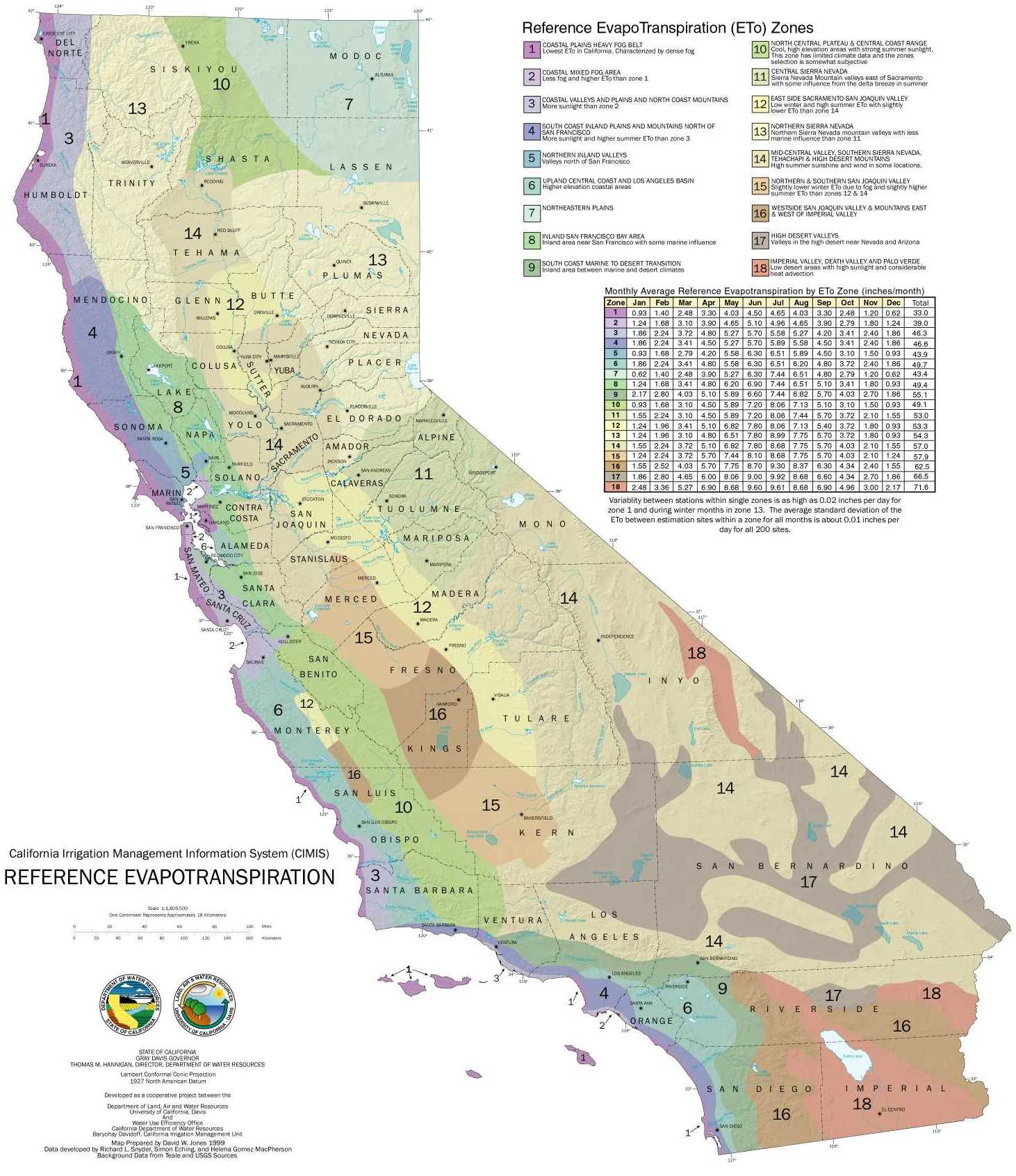
Reference ET Zones and monthly average ET values. Source: adapted from DWR, 2014, CIMIS Evapotranspiration Zones Map.

1. Total solar radiation (pyranometer)
2. Soil temperature (thermistor)
3. Air temperature/relative humidity (HMP35)
4. Wind direction (wind vane)
5. Wind speed (anemometer)
6. Precipitation (tipping-bucket rain gauge)

CIMIS station and sensor. Source: DWR, 2014, CIMIS stations.
The following resources provide more information on CIMIS and other irrigation assistance tools.
-
CIMIS portal, DWR/UC Cooperative Extension
-
UC Drought Management, evapotranspiration scheduling
-
Crop Manage overview: A web application for managing water and nitrogen fertilizer in lettuce, UCANR, 2012
-
Irrigation Water Use Management Best Management Practices, Texas Water Development Board, Conservation Division
Irrigation uniformity testing
Uniform distribution of water over a field ensures that plants are not getting over-watered in some areas and under-watered in others, as well as ensuring the uniform application of other inputs to promote plant health and growth. To test for uniformity of sprinkler irrigation systems, growers place cans that catch irrigation water in a grid and measure the volume caught in each. Relatively unequal volumes across a field informs the grower that something is impacting uniformity, whether blocked or partially-blocked sprinkler heads, exposure of various spots to more or less wind causing drift, or other factors. Achieving relative uniformity in several spots of the field should be the goal of the grower to maximize irrigation efficiency and avoid negative consequences of inefficient water allocation to plants, such as erosion, wilt, overly dry or overly saturated soils, etc. Growers have been applying a similar process during the last ten years to monitor drip irrigation uniformity in strawberry fields and vineyards, by comparing the volume of water captured in containers beneath emitters, as shown on the top right. In addition, several companies and the UC Cooperative Extension offices (UCCE) and Resource Conservation Districts (RCDs) as well as the Natural Resources Conservation Service offer irrigation management consulting services to farmers.
The following resource provides results from irrigation efficiency assessments from pump to field for several methods of irrigation on a range of crops.
-
Regional Irrigation Efficiency Program, Monterey County RCD/UC Department of Agriculture and Natural Resources (UCANR)/UCCE, 2012.


Irrigation Uniformity Test Methods. Source: Monterey County RCD/UCANR/UCCE, 2012, Regional Irrigation Efficiency Program, Power Point presentation.
Timing irrigations
In addition to the various soil moisture sensing technologies, several methods help growers determine when to irrigate. The increased cost of irrigation water, energy, and limited water supplies makes irrigation scheduling extremely important for growers. Several growers irrigate only at night to avoid drift from wind and water loss to evaporation, and also to reduce electricity costs by pumping during off-peak rate hours. If not able to irrigate at night, growers often try to at least avoid irrigating in the middle of the sunny and windy afternoons in the Salinas Valley. Aside from daily irrigation management, growers try to match crop water needs with water applied during specific stage of crop growth. Stages vary by crop, but generally crucial stages are during flowering, fruit production, and fruit filling (Whitney 2012).
Vintners have additional motivation for timing their irrigation schedule. By providing for less than the full potential vine water use, known as deficit irrigation, vintners can balance the vegetative growth of the canopy with the fruit to improve fruit quality while reducing water use. They can also cause deficits to occur at specific times in the season and at different severities to produce the desired fruit quality. This practice not only improves grape quality while reducing costs by pumping less water, but it also controls excess vegetative growth and therefore reduces disease susceptibility and hedging costs. In addition, this practice can reduce water and fertilizer losses (Pritchard 2004).
The following resources provide tips and tools for growers to utilize irrigation scheduling to optimize water use.
-
Deficit Irrigation of Quality Winegrapes Using Micro-Irrigation Techniques, UCANR, 2004
-
Irrigation Scheduling, UC Drought Management
Deficit Irrigation. Irrigating below total vine water use potential in this vineyard reduces water use by 13-60% at various times throughout the season. Source: Prichard et al, UCANR, 2004, Deficit Irrigation of Quality Winegrapes Using Micro-Irrigation Techniques.

Water harvesting
Several water saving practices, such as water harvesting, have nothing to do with irrigation systems or monitoring devices, but can help offset or reduce an operation’s groundwater pumping. Rainwater harvesting systems allow growers to accumulate water to irrigate and can be designed with features that control runoff, erosion and sediment. For example, one inch of rainfall on a 1500 square foot impervious roof generates approximately 1000 gallons of water. By contrast, one acre of crop requires 650,000 gallons of water (Burgoa 2014). Thus, rainwater harvesting is more likely to augment, not wholly supply, irrigation in commercial row crop operations. These systems can be modified to support many uses. Understanding the water-saving and cost-saving potential of such systems, some nursery greenhouses growing cut flowers installed rainwater collection systems to channel rainwater into storage tanks from the roofs using gutters and drain pipes. Systems are also useful in outdoor agriculture such as row-crops wherein ditches and/or subsurface drains enable growers to collect the water. Though water catchment systems are not used widely in Monterey County, the potential for on-farm water savings spurs adoption by some, one of whom is featured in a farmer highlight on our website.
Systems can also include filtration and purification components. Water drains into holding tanks or lined reservoirs and is pumped through the conveyance system to irrigation lines. Another method is using gravity to convey water when possible. Other harvesting alternatives include spring development, waterway diversion, subsurface collection via drywells and drains, and landscape collection from ponds and reservoirs. EQIP funding is currently available for water harvesting systems through NRCS.
Rainwater catchment.
Top: closed system rainwater catchment design for greenhouses
Bottom: design of catchment system using gutters on a hoop house.
Source: Casale, R., NRCS, 2014b, Water Harvesting on the Farm; Leopold Center, ISU Extension and Outreach, 2012, Rainwater Catchment from a High Tunnel for Irrigation Use.

These resources provide more information about water harvesting.
-
The Texas Manual on Rainwater Harvesting, Texas Water Development Board
-
Vendors list, Water Awareness Committee of Monterey County
-
Rainwater Catchment from a High Tunnel for Irrigation Use, Leopold Center, Iowa State University Extension and Outreach, 2012
Tailwater return systems
Another system growers can use to conserve water involves the reuse of the water running off the lower end of a field (tailwater) to irrigate crops, however the state Department of Water Resources strongly discourages its use for irrigation. Instead, growers use these systems for dust control. Despite the use of drip irrigation in all Monterey County vineyards, some vintners effectively integrate the tailwater systems to supplement irrigation for their vines. The use of tailwater return systems can also help growers comply with the MCWRA Water Conservation Ordinance to avoid un-collected runoff (MCWRA 1991). Although tailwater return systems are initially costly to implement and involve taking land out of production, they minimize environmental impacts of tailwater leaving fields (Schwankl et al 2007).
The following resource provides more information on the design, installation, cost and management of tailwater return systems.
-
Tailwater Return Systems, UC Department of Agriculture and Natural Resources (UCANR), 2007


Tailwater Return.
Left: Collection system.
Center: pipe discharge into collection pond.
Right: control, relief and check valves downstream from pump.
Source: Schwankl et al 2007, UCANR Publication 8225.
Other practices that promote water conservation
Water conservation is incidental in several other conservation practices growers implement to build soil health and reduce soil loss from erosion, optimize the use of inputs such as fertilizers and pesticides, and improve habitat for wildlife. Future installments of grower stewardship highlights on this website will feature those practices more in-depth. Several vegetative practices can reduce water use, such as cover crops, furrow bottom seeding, conservation cover, road seeding, windbreaks, hedgerows, critical area plantings, and buffer and filter strips.
These plantings can increase the ability for water to infiltrate the soil, while reducing and slowing runoff, thus preventing erosion of topsoil. They can also improve soil structure, reduce compaction, and increase organic matter, increasing the soil’s ability to hold water longer for crops to use. Management choices that help save water, in addition to those aforementioned, include seasonal and permanent fallowing of land, crop rotations with lower water use crops, no or reduced tillage, land leveling, mulching, and planting crops that can use nutrients and inputs efficiently given the soil type, terrain and microclimate. Soil health management practices such as composting, crop residue use, and nutrient management as well as structural practices such as water treatment/purification systems, subsurface drainage systems/dry wells, diversions, underground outlets, spring developments, recharge basins, irrigation ponds, and reservoirs can also save water on a farm (Casale 2014a).
The following resource provides more information on the additional ways growers can save water on their farms that are not often thought of or used for water-saving purposes.
-
The Forgotten Practices That Save Water on the Farm, Santa Cruz NRCS, 2014
Vegetative practices that promote water conservation. Source: The Forgotten Practices that Save Water on the Farm, PowerPoint presentation, Santa Cruz County NRCS, 2014.

Bibliography
1.Alliance for Water Efficiency, 2010, Soil Moisture Sensor Introduction
2.Alston & Bird, LLP, 2014, “California enacts unprecedented statewide groundwater regulation scheme”, Lexology, 16 Sep 2014.
3.Burgoa, B., RCDMC, 2014, personal communication, 18 Sep 2014.
4.California Department of Water Resources (DWR), 2014, Breaking Drought News: One of California’s Driest Years Ever.
5.—2014a, CIMIS Data.
6.Casale, Rich, Santa Cruz County NRCS, 2014, Agricultural Water Quality Alliance meeting, 13 Aug 2014.
7.— 2014a, Improving Soil Health Helps Conserve Water, July 2014 NRCS column article.
8.Central Coast Agricultural Water Quality Coalition, Efficiency Practices.
9.Dukes, M., M. Shedd, and B. Cardenas-Lailhacar, “Smart irrigation controllers: how do soil moisture sensor (SMS) irrigation
controllers work?” University of Florida IFAS Extension.
10.Greater Monterey County Integrated Regional Water Management Plan (GMCIRWMP), 2013, “Agricultural and Urban Water Use in
the Salinas Valley”, In: IRWMP for the Greater Monterey County Region, Apr 2013: B-58-60.
11.—“Seawater intrusion”, In: IRWMP for the Greater Monterey County Region, Apr 2013: B-79.
12.—“Water use trends”, In: IRWMP for the Greater Monterey County Region, Apr 2013: B-60.
13.Groot, N., 2014, “Farmers and ranchers are worried”, Farm Focus, Monterey County Farm Bureau, summer 2014.
14.Howitt, R., Medellin-Azuara, J., MacEwan, D., Lund, J., and D. Sumner, 2014. Economic Analysis of the 2014 Drought for California Agriculture. Center for Watershed Sciences, UC Davis, Davis, CA, 20 pp.
15.Keene, C., 2014, personal communication, 6 Oct 2014.
16.Monning, B., 2014, “Sen. Bill Monning: Central Coast benefits from water bond”, Santa Cruz Sentinel, 30 Aug 2014.
17.Monterey County RCD/Monterey County Agricultural Commissioner’s Office, 2013, Hillslope Farming Runoff Management Practices Guide
18.Monterey County RCD/UCANR/UCCE, 2012, Regional Irrigation Efficiency Program, Power Point presentation.
19.Monterey County Water Resources Agency (MCWRA), 1991, Agricultural Water Conservation Plan, Appendix: Guidelines for Agricultural Water Conservation Plans
20.—1995, “Section 4: Reservoir Operations”, In: Water Resources Data Report: Water Year 1995, p. 38.
21.—1996-2013, Ground Water Extraction Summary Reports 1995-2012.
22.—2010, Monterey County Groundwater Management Plan, 76pp.
23.—2012, Groundwater Elevation Contours, August Measurements for Pressure 180-Foot/400-Foot and East Side Shallow 1994-2011.
24.—2012a, Historic Seawater Intrusion Map, Pressure 180-Foot and 400-Foot Aquifer - 500 mg/L Chloride Areas
25.—2013, 2012 Ground Water Summary Report, Figure 5. Types of irrigation methods used in the Salinas Valley based on companies reported, p. 5.
26.—2013a, 2013 Irrigation and Nutrient Management Meeting, Power Point presentation 26 Feb 2013.
27.—2013b, Protective Elevations to Control Sea Water Intrusion in the Salinas Valley, Technical memorandum by Geoscience prepared for Monterey County Water Resources Agency, 36 pp.
28.Monterey Regional Water Pollution Control Agency (MRWPCA), 2013, “Recycled water.”
29.Neagley, J., and R. O’Brien, Jr., 1990, “Market allocation of agricultural water resources in the Salinas Valley”, graduate thesis, pp. 36-38.
30.Nirappil, F., and R. Giwargis, 2014. “Governor signs first California groundwater rules”, The Sacramento Bee. 16 Sep 2014.
31.Office of the Governor, Edmund G. Brown, Jr., 2014, Governor Brown declares drought state of emergency. 17 Jan 2014.
32.—2014a, Governor Brown signs legislation to put water bond before voters. 13 Aug 2014.
33.—2014b, Governor Brown signs historic groundwater legislation. 16 Sep 2014.
34.Pajaro Valley Water Management Agency (PVWMA), 2014, AG Water Conservation Toolkit, p. 8.
35.Prichard, T. et al, 2004, Deficit Irrigation of Quality Winegrapes Using Micro-irrigation Techniques, UCANR publ. 35507.
36.Schmalz, D., 2 Jan 2014. “2013 marks driest year in Monterey County history—by far”, Monterey County Weekly.
37.Schwankl, L., T. Prichard, T., and B. Hanson, 2007, Tailwater Return Systems, UCANR Publication 8225
38.Sims, W., 2 May 2014, “How the drought looks from the fields of Salinas Valley”, KUSP 88.9 Central Coast Public Radio podcast.
39.State Water Resources Control Board (SWRCB), California Environmental Protection Agency, 29 Jul 2014, “Mandatory Water Conservation Regulation Go Into Effect”, Fact Sheet.
40.Whitney, Kristen, USDA NRCS, 2012, Irrigation Water Management: the Key to Success Amidst Rising Water Costs, Between the Furrows, Farm Bureau April 2012 Newsletter.
41.UC Drought Management website.
42.USDA Economic Research Service (ERS), 2013, Irrigation &Water Use, USDA ERS website.
43.USDA/NOAA, 2014, US Drought Monitor, California
44.Watson, Montgomery, 1994. Salinas River Basin Water Resources Management Plan Task 1.09 Salinas Valley Ground Water Flow and Quality Model Report. Prepared for Monterey County Water Resources Agency. February 1994.
45.Weiser, M., 2014, “California poised to restrict groundwater pumping”, The Sacramento Bee, 15 Sep 2014.
46.Western Regional Climate Center, December 2013, WRCC climate region dry years, ranked by inches of precipitation. Accessed from DWR website.

Monterey County growers actively conserve and protect our vital natural resources in a variety of ways, but myriad challenges remain. This is the first installment in a series that highlights Monterey County growers’ ingenuity in taking steps to face environmental challenges. Our series begins with water conservation, set against California’s worst drought in decades. Assuring adequate water may be Monterey County agriculture's toughest test ever; this installment aims to promote practices that reduce agricultural water use. It remains the grower’s responsibility to use a combination of practices and approaches that use water more efficiently to save money and to conserve water on the farm. Following is an overview of local water issues and a brief summary of grower practices to conserve water now and in the future.